

http://en.wikipedia.org/wiki/Cradle_Mountain This link will give you more information about the region .
 The beginning of part IV and the end of my Tasmanian adventure starts at “The NUT” and in the quaint town of Stanley. This little gem of modern life is located on the north side and pretty close to the west corner of the island. The NUT is sort of like Ayers Rock/Uluru formation way out on a peninsula jutting into the Bass Strait. It’s commercialized and there’s a small ski lift that takes you to the top for $10. The paved and railed walk starts about half way up in the parking lot, right next to the gift shop and café. I was there shortly after sunrise; nothing was open and not a soul in sight. Exactly how I like my morning hikes! The climb took about 15 minutes and I have to admit was fairly steep. It was greater than a 45 degree angle all the way up. I stopped several times to admire view and catch my breath. Once on top and past the lift building the trail turned to dirt and levelled out. A welcome change for sure! The sun was just
  above the distant hills of eastern Tassie to my right. The field of 3’ tall grass glowed brightly before me glistening with morning dew. The trail lead around to the left along a fence and as I walked I notice they entire plateau was ravaged by rabbits holes everywhere. So many it was like honeycomb in a bee hive in some areas, the grass all bare and nibbled down. Surprisingly I didn’t see any rabbits at all. I did see one just as I left the parking lot but didn’t think anything of it. Australia does have well organized programs to eradicate certain non native invasive species of animals. So maybe the holes are left over from such a campaign?
See what so many days in the woods can do to you. You almost forget about the beautiful surrounding vistas while looking at the ground. As I looked up to the west you can see open ocean and the distant islands off the coast. Spinning my head around and I can look all the way down the edge of the island to the east. There are 2 large bays on either side, behind me, giving you a huge range view of sparkling blue waters, shimmering in the morning light. As I make my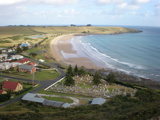 way around the fence line. I do come to pass 2 couples doing what looked like their morning ritual lap. On the back side the trial dips a little dropping into some woods and I wonder if it actually does go around. But the curious side of me keeps going assuming it must and I must see where it goes. Here I find a few pademelons but still no rabbits. (Pademelons don’t dig borrows) Coming out of the woods I find I’m just below the ski lift shed and the path back down. I stopped for a few minutes to capture this great view of the beach line and the city cemetery. After trekking back down the steep hillside I was hungry for some breaky. Knowing that there must have been a bakery some where I drive around the little town and find not only a great place for a sit down breakfast, Moby Dick’s. But that Stanley is very cool town. The ornately detailed Victorian style homes are all dolled up and fresh paint, lawns perfectly manicured, flowers lining the edges. This is a town that takes care of itself and it shows. While enjoying my bacon and eggs under an awning on the sidewalk I chat with the people from Sydney that come down every year to this secret hide away. It’s quickly becomes my favourite little town in Tasmania too. Maybe it was just a quiet Monday morning but this place had charm. I was told there are lots of B & B’s to stay at too. I think a future visit in in order. After my brush with the law is forgotten, of course.
 Once finished chatting I drove out of Stanley, Tasmania on my way to Rocky Cape National Park, just 20km (12.5 m) east. Another wonderful peninsula into the Bass Strait, but there was no commercialization here. Just a lighthouse, boat ramp, green covered hillsides and an 8,000 year old Aboriginal cave! It is considered a sacred site so I only took this picture of the cave, which was located about 100’ above the ocean. After investigated it and the boat ramp area I parked at the hiking trail head spot and walked up the closest hillside. The trail itself was hidden in the tough weather beaten shrubs. It could only be viewed from looking at it straight on
  line. The footsteps had ground down a path into the exposed rocks, keeping the trail obscured from any other angle. I slowly climbed the long switch back path up and around one dome then past several others, thinking each one was the peak this trail led too. I settle for a rocky outcrop after realizing why they called this the “Postman’s Pass”. It never does reach the peaks. It just keeps meandering past them. The views from here along the coast line are as magnificent as they have been in every spot I have stopped. The words to describe the many kilometres of coastal beauty have all been used up. There are only pictures.
 The drive up into the central mountain region and Cradle Mountain National Park takes a couple hours All the way those grey clouds keep getting thicker and heavier. The rain actually starts sporadically about 10km before I reach the main information centre. I was able to easily locate new my home away from home or the glorified tool shed as I’ve come to call it. Cabin #A2 is what the campground called it. Cabin or Tool Shed what do think? The shed is a 8’x8’ plywood box with a tin roof and 2 small triangular Plexiglas windows in the apex of the roof, front and back to let as much light in as possible and still keeping ones privacy.
  Inside there are 3 bunks, one on either side with the 3rd across the back a little higher hanging over the other two? I took all 3 foam mattresses and place them on one bed. After 8 nights in the car it’s going to be very nice to sleep fully reclined and on something a little softer. I unpack most of my gear and spread it out on the empty bunks. The rain is falling quite steadily, though not very hard. I check out the park services and made myself a massage appointment for New Years Eve. I also discover that there will be a live band in the bar at the main lodge to ring in 2009 with. By now I’m ready to rejoin society and hang out with someone beside the pademelons and gum trees. It’s late afternoon now and once I wandered around the park facilities it was time to do some laundry, clean up myself and the car. The evening was spent in a large camper’s kitchen building, socializing with the other campers, having my glass of vodka and staying out of the rain. The building itself has 2 kitchen areas with stove top, grill, microwaves and electric tea pot. In the centre of the room is a huge stone double fireplace. Wood is provided and a warm crackling fire is burning brightly on both sides. Helping keep all of us toasty and drying out various articles of clothing. There is 6 or 7 picnic tables spread around and even a lounge area with big leather couches. The first night in the shed is all I dreamed it could be. Dry, out of the wind, not to mention out of the car and VERY cold. I forgot to tell you the tool shed is void of electricity or heat. I used some lovely Asian style tea lanterns Michael gave me for lighting and every blanket I had, plus long johns, a t-shirt, a sweater, socks, a hat, gloves and hand warmers to keep me comfortable in the 3 C degree (40F) morning temperatures. As I drifted off to sleep the rain came down with a vengeance. The tin roof rattling with every rain drop, the wind
  whipping the trees. Which left me wondering if a branch was going to come crashing down to wake me in the night. In the cold morning air I quickly run outside to answer nature’s call and jump right back into bed. Sleeping in a little sounded like a GREAT idea. When I do rise about 8am I find not much has changed outside. It’s still windy, cold and wet. Just like New Years in Oregon should be! Except this year, I had heard that Oregon got 2’ of snow making me glad I was in Tassie. After breaky and checking my trail reference guides. I decide to take the shuttle bus up to Dove Lake and do the hike around it and then go from there. The lake is nestled in to a small valley and is about 2km long
 and maybe a ½ km wide. There’s a nicely maintained trail near the water’s edge all around it. At times Mother Nature does cooperate and the rain stops for 15 to 20 minutes. The deeply forested hillside surrounding the lake is lush and full of shades of green. In the distance you can see many waterfalls fully engorged with last night downpours. All that water rushing down the slopes into the lake. Fog gently covers the peaks and every once in a while 1 of the 2 mountain tops making up Cradle Mountain (sort of looks like saddle mountain doesn’t it) shows its beautiful face by peaking out between the clouds. Along the far end of the elliptically shaped lake
  the sparsely populated trees and shrubs become a full on rain forest. Trees and densely packed, with giant leaves shielding me from the raindrops and protecting my from the wind. I’m fairly soaked by this point so any protection is a good thing. The wooden board walk trail is elevated and that is also a good thing as most of the streams have expanded far beyond their normal banks and the forest floor is more of a single all encompassing waterfall with the torrents of
  water taking no prisoners on its long journey to the sea and off these mountains. I rounded the back side and started my way back to the trail head I the clouds parted and the sun came out as I left the dense rain forest area. Some dry weather for walking was exactly what this trek needed. Rising up over one of the ridges I was able to find a dry spot on a wooden bench. There are a few other people around on this trial but I have this sunny spot all to myself. The bench faces back towards the big waterfalls, giving a awesome view off several. You can hear thousands of little water falls in the forest beyond me, you can hear the winds sweeping over the hillside, down into the valleys, rustling the treetops. Small clouds passing in front of the sun cast a shadow over the foliage causing the colors to change from a dark ominous green to a bright, alive, vivid green and back again. For a few minutes I lose myself there. Trying to use all of my senses to absorb as much of the things happening around me as possible. All of a sudden something grabs at my hand and the granola fruit bar I’m holding, startling me with a jump. It’s a large raven with yellow beady eyes. He has literally just tried to steal the food from me. This is one brave, aggressive bird. I had to shoo him away and then again 30 seconds later. He kept coming back until I had long finished the food and I finally found a few small pebbles to throw at him. See what feeding the animals can do. But they’re so darn cute sometimes I just can’t help myself.
I continued on the trail and get back to the starting point fairly dry and feeling good. Eager enough to keep going. So I head along the boardwalk back to the visitor centre. An 8km hike broken into 3 sections or a 15 minute shuttle bus trip. For the most part this area is beautiful but slightly boring. You walk up and down around the corners past more trees and grasses. Occasionally crossing Dove River that is the outfall to the lake, paralleling the roadway about 100m (300’) to one side. Before reaching Ronny Creek parking area I connect with a section of the Overland Track which is a 80+ km trail from these mountains south all the way to South Cape Bay and the Cockle Creek campground (see Tasmania part II) This particular section is an open field. The boardwalk managed to keep you up out of the marshes but was in need of some repair in spots. As I walk along I notice something I had heard about many time but not seen, Wombat Poo! A Wombat is a good size animal, kind of like a black bear cub with a slightly less aggressive (only slightly) personality. These creatures are vegetarians and eat mostly grasses and leaves. What is most unique about them and the part so many people have shared with me is that their poo is square. Yep I said square! Now I have spared you the picture but take my word for it these brown little grainy turds look like large dice that have been passed and of course plopped down right in the middle of the trail. It’s EVERYWHERE! Every 3rd step I have to make sure I know exactly where I’m placing my foot. The little piles are in various stages of decay. It is on the walkway, in the grasses, floating in the creek beds the snaked between the mounds of grass. Really there’s a lot of poo for over 2 full km. Making me wonder how many wombats frequent what must be some really yummy grass. There was one more thing I noticed that kind of amazed me. There was no smell, at least not what one would imagine you should have standing in a massive field filled with crap. But nothing I could really notice? Maybe it was the wind and rain keeping down the smell. Whatever it was I was thankful and did my best to get finished the wombat poo trail as fast as possible. At 2nd of the 3 connection point with the shuttle bus I decided to take the more leisurely route home and planted my butt on the bus for the final 2.5 km. I spent the evening much like the one before in the mess hall enjoy a warm fire, vodka and the company of strangers. Some people were new and some, I had met the evening before. The night was also spent much the same way snuggled up in my layers of cotton. Listing to the wind and rain, fairly confident I wouldn’t get crushed by a tree limb. It hadn’t happened on the first night so it was harder to believe it would happen tonight.
 Wednesday morning, New Year’s Eve day, I awoke to more of the same thing, single digit temperatures, biting wind and rain. Today’s adventures will take me to one of the peaks above Dove lake and crappy weather isn’t going to stop me from getting in one more decent hike on the final days of my trip. I do have a 90 minute massage booked for 5pm, dinner in the bar, and a live band planned for the evening giving me something to look forward to at my journey’s end. I start out back at Ronny Creek trail head and Wombat Poo Trail. I have to back track on about 1km of trail I did yesterday to get to
  the turn on to the Overland Track and up to Marion’s lookout. Along the way you pass another mountain lake, Crater Lake. Much smaller then the famed National Park of Oregon I love so much. But beautiful in its own right. The trail takes you right up the river that overflows out of it. The 2nd day of rain has continued to push the water through the forest at high peak flows making every wet step worth it. Today weather is a little different, instead of fairly constant rain like yesterday it was heavy down pours for a few minutes then nice sun shine. So as I continue to climb past Crater Lake the vegetation gets more like mountain scrub not giving you much protection from the elements along with beautiful vista when the sun does come out. I make my way to the final plateau with my destination insight. I chat with a nice lady making her way down, but waiting up for her husband to catch up. We can see the clouds coming off the hills. Dark, ominous clouds, clouds you can see pack a wallop and there’s nowhere to hide. The last .5km, 120m (390') climb isn’t going to be of the sunny pretty nature I'd prefer, it turns out to be a head down, watch your feet closely and a highly vertical one instead.
The lookout's view point tops out at about 1200m, (3940') which doesn’t sound like much but this tiny island peaks out at 1545m (5070')and is exposed to the Mother Nature’s wrath, surrounded by hundreds or thousands of miles of ocean. Reaching the top the rain that had turned to sleet, pelting me, then turned to snow, whipping past me, with winds that cause you to want to hold on to something. I find a magnificent spot, a little gully dip at the edge looking over Dove Lake. This spot is flat with a back wall about a meter high to lean up against keeping the wind and snow at my back whipping right over my head. Eventually the skies do clear a little and more people show up. I have had my 30 minutes rest at the perfect spot and now it's time for someone else to use it. Making my way back down is always a quicker trip but I manage to catch a great shot of Crater and Wilkes Lake. (There's also a Hanson Lake and about 4 more nestled in the tiny valley's created by the peaks above Dove Lake.) Back at camp I take a quick shower not because I’m late for my massage but because the water is barely luke warm and the shower building is made of stone with big open doorways allowing the cold wind practically into the shower stall with you. I make it to the spa, where I’m givin the 3 second tour (it’s that small) and a robe. I sit in the steam room and warm myself thoroughly. The massage is wonderful and does exactly what I needed after all my time outside and on the trails.
Thursday morning, January 1 2009 was a new day, a new year and new adventures waited for me. I still had 1 full day left before heading back to Melbourne and wanted to start the year off right, with more national parks. I only have to make it to Devonport a mere 100km away today. I leave Cradle Mountain and head for Mole Creek Karst National Park and another cave system. There are actually several in this area to visit. Mole Creek being the most popular and where the information centre is located. Here the guide doesn’t mention the cave spiders at all. I do ask about them and he prefers to not mention it but they are there too. This place is just as beautiful as Hastings Cave (see Tasmania part II) but they have a much more spectacular showing of glow worms. Near the end of our journey the group came to a spot where the guide shut off all of the lights. If you’ve never been in a cave and had this done it’s an eye opening experience, trust me. You absolutely cannot see you hand in front of your face even if you were touching your nose. Once your eyes fully expanded to the light that was in this area you could see hundreds of little bright white spots on the ceiling and walls. Waiting further
  allows you to see the lights reflecting in the pool of water near us. I tried to get a picture but it just didn’t come out very well. It was really a cool thing to these guys. It’s really just the tip of their tails that glows and they do it to attract insect in the darkness. They’re only about an inch long and are another unique cave creature.
Still having most of the afternoon left I manage to squeeze in my 11th national park in 12 days, Narawntapu National Park just east of Devonport another beach park that prove to be one of the best. I arrive at the trail head which is only about 60m (200') from the beach and like so many places on this wonderful journey there’s no one around. Coming out of the mountains meant the rain had stopped and the sun was shining brightly again. A solemn, secluded walk on the beach to clear my head and think of all the fun I have had. The beach was long and straight stretching for maybe 5 km in each direction, with firm warm sand to walk in, a gentle ocean breeze, lapping 1’ waves and endless serenity. My hotel awaits me for the final nights rest but I linger here most, of all the places, not wanting to return fully to the hard brash surfaces of our modern world.
After checking in to the Comfort Inn I find some dinner and return to the comfort of those hard brash surfaces and a warm and soft bed. A real bed with sheets and pillows and blankets. A world of HOT showers and mindless TV. Even here I lose track of the time and drift off into sleep with my CPAP purring along next to me. Friday morning I’m up and on my way at 7am . Boarding on the Spirit of Tassie back to the main land starts at 7:30. The long ride home on Tasmania’s finest auto ferry awaits me. This is just like the trip down but less exciting because I know what to expect this time. I won’t bore you or myself with the details again. One thing I didn’t expect was the feeling of seeing Melbourne and the anticipation I’d feel at returning to the new city that has become familiar to me. It’s the first time I heard myself refer to it as home. To this day I’m still trying to understand what the bigger meaning of that single thought is and what it means to my life. You’ll have to keep reading my blogs to find out, as I do.
 The beginning of part IV and the end of my Tasmanian adventure starts at “The NUT” and in the quaint town of Stanley. This little gem of modern life is located on the north side and pretty close to the west corner of the island. The NUT is sort of like Ayers Rock/Uluru formation way out on a peninsula jutting into the Bass Strait. It’s commercialized and there’s a small ski lift that takes you to the top for $10. The paved and railed walk starts about half way up in the parking lot, right next to the gift shop and café. I was there shortly after sunrise; nothing was open and not a soul in sight. Exactly how I like my morning hikes! The climb took about 15 minutes and I have to admit was fairly steep. It was greater than a 45 degree angle all the way up. I stopped several times to admire view and catch my breath. Once on top and past the lift building the trail turned to dirt and levelled out. A welcome change for sure! The sun was just
  above the distant hills of eastern Tassie to my right. The field of 3’ tall grass glowed brightly before me glistening with morning dew. The trail lead around to the left along a fence and as I walked I notice they entire plateau was ravaged by rabbits holes everywhere. So many it was like honeycomb in a bee hive in some areas, the grass all bare and nibbled down. Surprisingly I didn’t see any rabbits at all. I did see one just as I left the parking lot but didn’t think anything of it. Australia does have well organized programs to eradicate certain non native invasive species of animals. So maybe the holes are left over from such a campaign?
See what so many days in the woods can do to you. You almost forget about the beautiful surrounding vistas while looking at the ground. As I looked up to the west you can see open ocean and the distant islands off the coast. Spinning my head around and I can look all the way down the edge of the island to the east. There are 2 large bays on either side, behind me, giving you a huge range view of sparkling blue waters, shimmering in the morning light. As I make my
 way around the fence line. I do come to pass 2 couples doing what looked like their morning ritual lap. On the back side the trial dips a little dropping into some woods and I wonder if it actually does go around. But the curious side of me keeps going assuming it must and I must see where it goes. Here I find a few pademelons but still no rabbits. (Pademelons don’t dig borrows) Coming out of the woods I find I’m just below the ski lift shed and the path back down. I stopped for a few minutes to capture this great view of the beach line and the city cemetery. After trekking back down the steep hillside I was hungry for some breaky. Knowing that there must have been a bakery some where I drive around the little town and find not only a great place for a sit down breakfast, Moby Dick’s. But that Stanley is very cool town. The ornately detailed Victorian style homes are all dolled up and fresh paint, lawns perfectly manicured, flowers lining the edges. This is a town that takes care of itself and it shows. While enjoying my bacon and eggs under an awning on the sidewalk I chat with the people from Sydney that come down every year to this secret hide away. It’s quickly becomes my favourite little town in Tasmania too. Maybe it was just a quiet Monday morning but this place had charm. I was told there are lots of B & B’s to stay at too. I think a future visit in in order. After my brush with the law is forgotten, of course.
 Once finished chatting I drove out of Stanley, Tasmania on my way to Rocky Cape National Park, just 20km (12.5 m) east. Another wonderful peninsula into the Bass Strait, but there was no commercialization here. Just a lighthouse, boat ramp, green covered hillsides and an 8,000 year old Aboriginal cave! It is considered a sacred site so I only took this picture of the cave, which was located about 100’ above the ocean. After investigated it and the boat ramp area I parked at the hiking trail head spot and walked up the closest hillside. The trail itself was hidden in the tough weather beaten shrubs. It could only be viewed from looking at it straight on
  line. The footsteps had ground down a path into the exposed rocks, keeping the trail obscured from any other angle. I slowly climbed the long switch back path up and around one dome then past several others, thinking each one was the peak this trail led too. I settle for a rocky outcrop after realizing why they called this the “Postman’s Pass”. It never does reach the peaks. It just keeps meandering past them. The views from here along the coast line are as magnificent as they have been in every spot I have stopped. The words to describe the many kilometres of coastal beauty have all been used up. There are only pictures.
 The drive up into the central mountain region and Cradle Mountain National Park takes a couple hours All the way those grey clouds keep getting thicker and heavier. The rain actually starts sporadically about 10km before I reach the main information centre. I was able to easily locate new my home away from home or the glorified tool shed as I’ve come to call it. Cabin #A2 is what the campground called it. Cabin or Tool Shed what do think? The shed is a 8’x8’ plywood box with a tin roof and 2 small triangular Plexiglas windows in the apex of the roof, front and back to let as much light in as possible and still keeping ones privacy.
  Inside there are 3 bunks, one on either side with the 3rd across the back a little higher hanging over the other two? I took all 3 foam mattresses and place them on one bed. After 8 nights in the car it’s going to be very nice to sleep fully reclined and on something a little softer. I unpack most of my gear and spread it out on the empty bunks. The rain is falling quite steadily, though not very hard. I check out the park services and made myself a massage appointment for New Years Eve. I also discover that there will be a live band in the bar at the main lodge to ring in 2009 with. By now I’m ready to rejoin society and hang out with someone beside the pademelons and gum trees. It’s late afternoon now and once I wandered around the park facilities it was time to do some laundry, clean up myself and the car. The evening was spent in a large camper’s kitchen building, socializing with the other campers, having my glass of vodka and staying out of the rain. The building itself has 2 kitchen areas with stove top, grill, microwaves and electric tea pot. In the centre of the room is a huge stone double fireplace. Wood is provided and a warm crackling fire is burning brightly on both sides. Helping keep all of us toasty and drying out various articles of clothing. There is 6 or 7 picnic tables spread around and even a lounge area with big leather couches. The first night in the shed is all I dreamed it could be. Dry, out of the wind, not to mention out of the car and VERY cold. I forgot to tell you the tool shed is void of electricity or heat. I used some lovely Asian style tea lanterns Michael gave me for lighting and every blanket I had, plus long johns, a t-shirt, a sweater, socks, a hat, gloves and hand warmers to keep me comfortable in the 3 C degree (40F) morning temperatures. As I drifted off to sleep the rain came down with a vengeance. The tin roof rattling with every rain drop, the wind
  whipping the trees. Which left me wondering if a branch was going to come crashing down to wake me in the night. In the cold morning air I quickly run outside to answer nature’s call and jump right back into bed. Sleeping in a little sounded like a GREAT idea. When I do rise about 8am I find not much has changed outside. It’s still windy, cold and wet. Just like New Years in Oregon should be! Except this year, I had heard that Oregon got 2’ of snow making me glad I was in Tassie. After breaky and checking my trail reference guides. I decide to take the shuttle bus up to Dove Lake and do the hike around it and then go from there. The lake is nestled in to a small valley and is about 2km long
 and maybe a ½ km wide. There’s a nicely maintained trail near the water’s edge all around it. At times Mother Nature does cooperate and the rain stops for 15 to 20 minutes. The deeply forested hillside surrounding the lake is lush and full of shades of green. In the distance you can see many waterfalls fully engorged with last night downpours. All that water rushing down the slopes into the lake. Fog gently covers the peaks and every once in a while 1 of the 2 mountain tops making up Cradle Mountain (sort of looks like saddle mountain doesn’t it) shows its beautiful face by peaking out between the clouds. Along the far end of the elliptically shaped lake
  the sparsely populated trees and shrubs become a full on rain forest. Trees and densely packed, with giant leaves shielding me from the raindrops and protecting my from the wind. I’m fairly soaked by this point so any protection is a good thing. The wooden board walk trail is elevated and that is also a good thing as most of the streams have expanded far beyond their normal banks and the forest floor is more of a single all encompassing waterfall with the torrents of
  water taking no prisoners on its long journey to the sea and off these mountains. I rounded the back side and started my way back to the trail head I the clouds parted and the sun came out as I left the dense rain forest area. Some dry weather for walking was exactly what this trek needed. Rising up over one of the ridges I was able to find a dry spot on a wooden bench. There are a few other people around on this trial but I have this sunny spot all to myself. The bench faces back towards the big waterfalls, giving a awesome view off several. You can hear thousands of little water falls in the forest beyond me, you can hear the winds sweeping over the hillside, down into the valleys, rustling the treetops. Small clouds passing in front of the sun cast a shadow over the foliage causing the colors to change from a dark ominous green to a bright, alive, vivid green and back again. For a few minutes I lose myself there. Trying to use all of my senses to absorb as much of the things happening around me as possible. All of a sudden something grabs at my hand and the granola fruit bar I’m holding, startling me with a jump. It’s a large raven with yellow beady eyes. He has literally just tried to steal the food from me. This is one brave, aggressive bird. I had to shoo him away and then again 30 seconds later. He kept coming back until I had long finished the food and I finally found a few small pebbles to throw at him. See what feeding the animals can do. But they’re so darn cute sometimes I just can’t help myself.
 I continued on the trail and get back to the starting point fairly dry and feeling good. Eager enough to keep going. So I head along the boardwalk back to the visitor centre. An 8km hike broken into 3 sections or a 15 minute shuttle bus trip. For the most part this area is beautiful but slightly boring. You walk up and down around the corners past more trees and grasses. Occasionally crossing Dove River that is the outfall to the lake, paralleling the roadway about 100m (300’) to one side. Before reaching Ronny Creek parking area I connect with a section of the Overland Track which is a 80+ km trail from these mountains south all the way to South Cape Bay and the Cockle Creek campground (see Tasmania part II) This particular section is an open field. The boardwalk
 managed to keep you up out of the marshes but was in need of some repair in spots. As I walk along I notice something I had heard about many time but not seen, Wombat Poo! A Wombat is a good size animal, kind of like a black bear cub with a slightly less aggressive (only slightly) personality. These creatures are vegetarians and eat mostly grasses and leaves. What is most unique about them and the part so many people have shared with me is that their poo is square. Yep I said square! Now I have spared you the picture but take my word for it these brown little grainy turds look like large dice that have been passed and of course plopped down right in the middle of the trail. It’s EVERYWHERE! Every 3rd step I have to make sure I know exactly where I’m placing my foot. The little piles are in various stages of decay. It is on the walkway, in the grasses, floating in the creek beds the snaked between the mounds of grass. Really there’s a lot of poo for over 2 full km. Making me wonder how many wombats frequent what must be some really yummy grass. There was one more thing I noticed that kind of amazed me. There was no smell, at least not what one would imagine you should have standing in a massive field filled with crap. But nothing I could really notice? Maybe it was the wind and rain keeping down the smell. Whatever it was I was thankful and did my best to get finished the wombat poo trail as fast as possible. At 2nd of the 3 connection point with the shuttle bus I decided to take the more leisurely route home and planted my butt on the bus for the final 2.5 km. I spent the evening much like the one before in the mess hall enjoy a warm fire, vodka and the company of strangers. Some people were new and some, I had met the evening before. The night was also spent much the same way snuggled up in my layers of cotton. Listing to the wind and rain, fairly confident I wouldn’t get crushed by a tree limb. It hadn’t happened on the first night so it was harder to believe it would happen tonight.
 Wednesday morning, New Year’s Eve day, I awoke to more of the same thing, single digit temperatures, biting wind and rain. Today’s adventures will take me to one of the peaks above Dove lake and crappy weather isn’t going to stop me from getting in one more decent hike on the final days of my trip. I do have a 90 minute massage booked for 5pm, dinner in the bar, and a live band planned for the evening giving me something to look forward to at my journey’s end. I start out back at Ronny Creek trail head and Wombat Poo Trail. I have to back track on about 1km of trail I did yesterday to get to
  the turn on to the Overland Track and up to Marion’s lookout. Along the way you pass another mountain lake, Crater Lake. Much smaller then the famed National Park of Oregon I love so much. But beautiful in its own right. The trail takes you right up the river that overflows out of it. The 2nd day of rain has continued to push the water through the forest at high peak flows making every wet step worth it. Today weather is a little different, instead of fairly constant rain like yesterday it was heavy down pours for a few minutes then nice sun shine. So as I continue to climb past Crater Lake the vegetation gets more like mountain scrub not giving you much protection from the elements along with beautiful vista when the sun does come out. I make my way to the final plateau with my destination insight. I chat with a nice lady making her way down, but waiting up for her husband to catch up. We can see the clouds coming off the hills. Dark, ominous clouds, clouds you can see pack a wallop and there’s nowhere to hide. The last .5km, 120m (390') climb isn’t going to be of the sunny pretty nature I'd prefer, it turns out to be a head down, watch your feet closely and a highly vertical one instead.
The lookout's view point tops out at about 1200m, (3940') which doesn’t sound like much but this tiny island peaks out at 1545m (5070')and is exposed to the Mother Nature’s wrath, surrounded by hundreds or thousands of miles of ocean. Reaching the top the rain that had turned to sleet, pelting me, then turned to snow, whipping past me, with winds that cause you to want to hold on to something. I find a magnificent spot, a little gully dip at the edge looking over Dove Lake. This spot is flat with a back wall about a meter high to lean up against keeping the wind and snow at my back whipping right over my head. Eventually the skies do clear a little and more people show up. I have had my
 30 minutes rest at the perfect spot and now it's time for someone else to use it. Making my way back down is always a quicker trip but I manage to catch a great shot of Crater and Wilkes Lake. (There's also a Hanson Lake and about 4 more nestled in the tiny valley's created by the peaks above Dove Lake.) Back at camp I take a quick shower not because I’m late for my massage but because the water is barely luke warm and the shower building is made of stone with big open doorways allowing the cold wind practically into the shower stall with you. I make it to the spa, where I’m givin the 3 second tour (it’s that small) and a robe. I sit in the steam room and warm myself thoroughly. The massage is wonderful and does exactly what I needed after all my time outside and on the trails.
 Dinner on New Years Eve was spent in the lodge bar off to one side where I could watch the whole dining room and overlook the bar area. I treated myself to a big juicy steak. During dinner I'm able to make out who the locals are. They tend to be having much more fun because they’re so isolated and really get to know each other and it is the last day of 2008. The band I had heard so much about turned out to be a guy with a guitar and a harmonica and he was good. His repartee was lots of old classics to get the crowd singing and dancing. I met several great people and party the night away welcoming in 2009.
Thursday morning, January 1 2009 was a new day, a new year and new adventures waited for
 me. I still had 1 full day left before heading back to Melbourne and wanted to start the year off right, with more national parks. I only have to make it to Devonport a mere 100km away today. I leave Cradle Mountain and head for Mole Creek Karst National Park and another cave system. There are actually several in this area to visit. Mole Creek being the most popular and where the information centre is located. Here the guide doesn’t mention the cave spiders at all. I do ask about them and he prefers to not mention it but they are there too. This place is just as beautiful as Hastings Cave (see Tasmania part II) but they have a much more spectacular showing of glow worms. Near the end of our journey the group came to a spot where the guide shut off all of the lights. If you’ve never been in a cave and had this done it’s an eye opening experience, trust me. You absolutely cannot see you hand in front of your face even if you were touching your nose. Once your eyes fully expanded to the light that was in this area you could see hundreds of little bright white spots on the ceiling and walls. Waiting further
  allows you to see the lights reflecting in the pool of water near us. I tried to get a picture but it just didn’t come out very well. It was really a cool thing to these guys. It’s really just the tip of their tails that glows and they do it to attract insect in the darkness. They’re only about an inch long and are another unique cave creature.
Still having most of the afternoon left I manage to squeeze in my 11th national park in 12 days, Narawntapu National Park just east of Devonport another beach park that prove to be one of the best. I arrive at the trail head which is only about
 60m (200') from the beach and like so many places on this wonderful journey there’s no one around. Coming out of the mountains meant the rain had stopped and the sun was shining brightly again. A solemn, secluded walk on the beach to clear my head and think of all the fun I have had. The beach was long and straight stretching for maybe 5 km in each direction, with firm warm sand to walk in, a gentle ocean breeze, lapping 1’ waves and endless serenity. My hotel awaits me for the final nights rest but I linger here most, of all the places, not wanting to return fully to the hard brash surfaces of our modern world.
After checking in to the Comfort Inn I find some dinner and return to the comfort of those hard brash surfaces and a warm and soft bed. A real bed with sheets and pillows and blankets. A world of HOT showers and mindless TV. Even here I lose track of the time and drift off into sleep with my CPAP purring along next to me. Friday morning I’m up and on my way at 7am . Boarding on the Spirit of Tassie back to the main land starts at 7:30. The long ride home on Tasmania’s finest auto ferry awaits me. This is just like the trip down but less exciting because I know what to expect this time. I won’t bore you or myself with the details again. One thing I didn’t expect was the feeling of seeing Melbourne and the anticipation I’d feel at returning to the new city that has become familiar to me. It’s the first time I heard myself refer to it as home. To this day I’m still trying to understand what the bigger meaning of that single thought is and what it means to my life. You’ll have to keep reading my blogs to find out, as I do.


